How can we help you?
Disclaimer
All information contained on this site is for information purposes only and should not be relied upon. For the authoritative 'Definitive Map' contact the area's local authority.
My Location
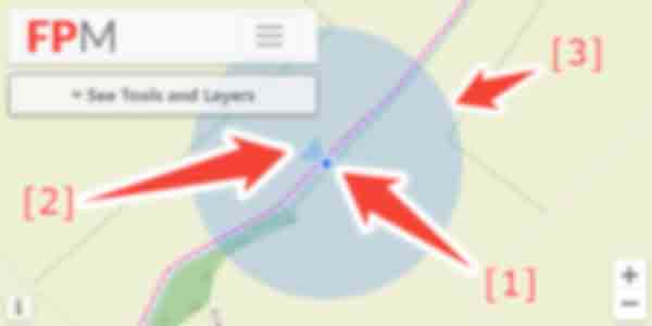
This uses your device's location feature to place a marker on the map where you are.
-
Position: shows the centre of your position on the map.
- For the website to be able to access your location, you will often need to accept a permissions dialogue from your browser asking for your consent.
- If you are using a device without any way of detecting your actual location (e.g. a laptop or desktop) the browser will only be able to roughly estimate your location.
- Compass: the direction you are facing.
- Accuracy: shows the reported 'accuracy' of the position. This means your device is currently unable to be more specific and you may be located anywhere within the outer circle and not necessarily directly in the centre.
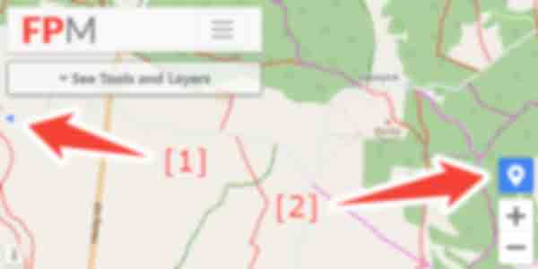
Once you move the map such that your position is not longer visible, the following features will appear:
- Bearing: the direction you would travel to get from the centre of the map to your current physical position.
- Centre Me: re-centres the map on your location.
Map Key
Displays a key which lists the meaning of the lines and some features / areas.
Location in Google Maps
Opens Google Maps in a new tab exactly in the same location as you are viewing.
Draw Route / Favourite Location
Feature Moved: See "My Places Library"Save Offline Image
Saves the current map view to an image.
Footpath, Bridleway, Byway
-
Core layer showing lines for:
- Red: FootPath
- Green: Restricted Byway
- Blue: Byway
- Magenta: Bridleway
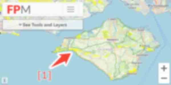
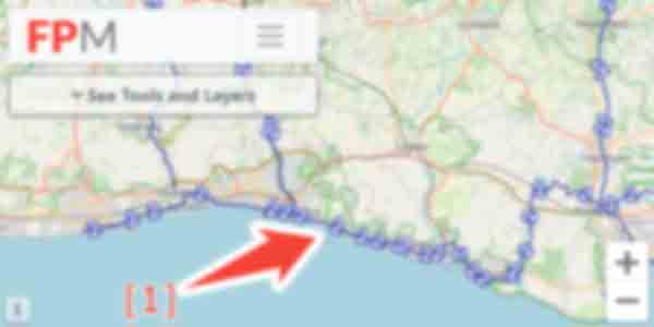
National Trails / Coastal Path
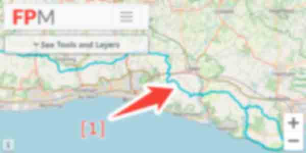
- Layer showing National Trails and Coastal Path.
Right to Roam
- Layer showing areas of Right to Roam.
Cycle Network
-
Layer showing National Cycle Network.
- Number corresponds to route and will also be displayed on the signposts.
Draw New Route
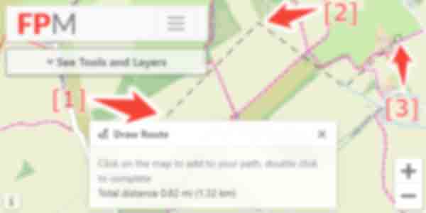
- Click on the button in the menu, then press anywhere on the map to add the first point.
- Click again for each subsequent point along the route.
- Double click to complete the line.
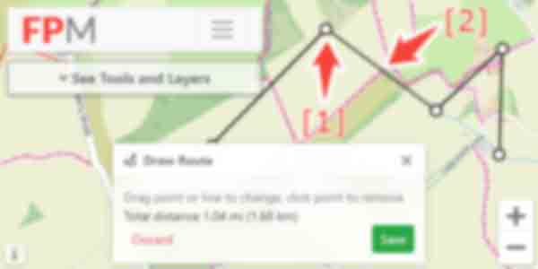
- Move existing points by dragging.
- Add new points by clicking and dragging on a line.
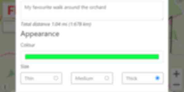
- For saved routes you can edit their details by clicking on the line.
- Edit options allow you to customise name, colour, and size.
- To edit the route shape, click "Edit Route" at the bottom of the dialogue.
Add Favourite Location
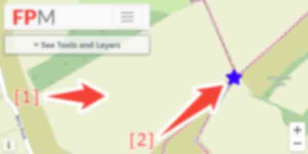
- Click on the button in the menu, then press anywhere on the map to add a point.
- Press again on any point to open the edit dialogue.
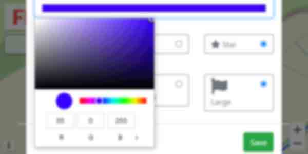
- Edit options allow you to customise name, colour, size, and symbol.
Importing GPX
- Click the button next to
- Select Import GPX and follow the instructions.
Exporting GPX
- Find the route on the map and click on its line to open the "Edit Route" dialogue.
- Select then "Download GPX"
Grouping Routes & Locations
- Each route and location is stored in a named "Folder"
- These will show alphabetically within the "My Places Library" section in the tools menu.
- Click on the name to toggle the display of the whole folder on and off.
Hiding Routes
- Each folder can be set to be automatically shown or hidden when the map first loads.
- To change this, click the button next to the folder.
- To hide and show specific routes, edit the route and move it to and from a folder which is not visible.
Hills
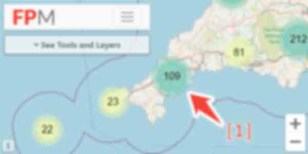
- Zoomed out shows number of hills grouped into clusters.
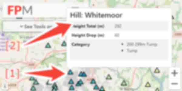
-
Once zoomed in far enough, individual hills are shown as triangles.
- Darker colour signifies higher hill.
- Hills can be clicked on for further details.
National Trust


-
Layer showing National Trust locations.
- Orange dots give indication of entry price.
- Click on point to view further details.
English Heritage


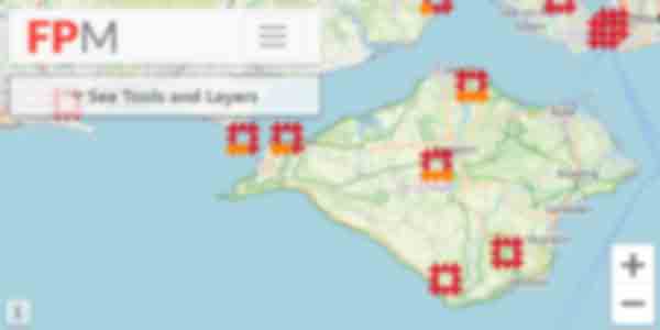
-
Layer showing Heritage locations.
- Orange dots give indication of entry price.
- Click on point to view further details.
Country Parks

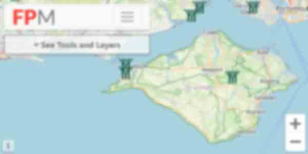
- Layer showing Country Park locations.
Open Street Map
-
OpenStreetMap
- Produced via a collaborative project to create a free map of the world.
Ordnance Survey
-
Ordnance Survey
- The national mapping agency for Great Britain.
Satellite View
-
Satellite View
- High Resolution Satellite Imagery.
1900s Historic Map
-
1900s Historic Map
- Great Britain, Ordnance Survey six-inch to the mile (1:10,560), 1888-1913.
You may cancel your subscription by clicking on "My Account". Open the "My Subscription" panel by clicking it, find your active subscription in the list. On the right hand side of the table there is a "Cancel" button.
You may update your card details by clicking on "My Account". Open the "My Subscription" panel by clicking it, then select the "Update Card" button.
If no button is show, they do not have an active subscription.
Unfortunately at this time we do not produce a mobile application, the website is however designed to work well on a mobile device and has features such as location and orientation which work correctly in the browser.
Our website supports devices running iOS 15 or later. If you're using an earlier version of iOS, you'll need to update your device (if supported).
Please note that switching to a different browser on an unsupported version of iOS will not resolve compatibility issues, as all browsers on iOS use the same underlying browser engine.
If you experience any issues using the website, please contact us and we'll be happy to help.
The base map layer we use is from OpenStreetMap, a "collaborative project to create a free editable map of the world". A small subset of the public rights of way have been added by their users, and these show up as dashed lines.
A full OpenStreetMap key is available here: wiki.openstreetmap.org/wiki/OpenStreetMap_Carto/Lines
The base map layer we use is from OpenStreetMap, this is then overlaid with the official council right of way data shown as solid red/blue/magenta/green lines.
Due to discrepancies / inaccuracies of the data, both sets of lines may not occur in identical locations and can both be displayed, often very close to each other.
Please first ensure that you have checked that the path does not appear on your council's online interactive right of way map (if they publish one). Most links can be found from the search page by clicking on your council area and then using the links at the bottom of the page.
Next, please contact us using the form below, ideally providing a postcode of the problem area. We will then reply and ask for you to submit a screenshot.
The faint dotted red lines come from the OpenStreetMap project: https://www.openstreetmap.org which is the base map layer we use and is not something we have any control over or affiliation with.
The OpenStreetMap project is however a publicly editable map so you may be able to remove these paths yourself using the tools available on their website.
In our map key only the solid lines are listed as public right of ways; we specifically have a warning to only follow signposted paths and to be careful with the OpenStreetMap lines as many of them are not public.
All the map features apart from the right of way lines come from the OpenStreetMap project: https://www.openstreetmap.org which is the base map layer we use and is not something we have any control over or affiliation with.
The OpenStreetMap project is however a publicly editable map so you may be able to edit these features yourself using the tools available on their website.
All feedback (good or bad) is appreciated. Please use the form below to contact us.
If you have found a physical problem with a right of way you will need to report it to your local authority. You can report problems such as:
- Overgrown plants or weeds.
- Footpath or bridleway needing repair.
- Obstructions on the rights of way such as vehicles, or dead animals.
- Damaged bridge.
- Broken gates.
Most local authorities will have a form you can fill in on their website. This can usually be found by going to the search page, selecting your county and then there will be links at the bottom for the local authorities right of way pages.
Unfortunately we are unable to help with such enquiries.
Attribution
| Contains OS data © Crown copyright and database right 2026 |
| Contains Royal Mail data © Royal Mail copyright and Database right 2026 |
| Contains public sector information licensed under the Open Government Licence v3.0 |
| Contains National Statistics data © Crown copyright and database right 2026 |
| © OpenStreetMap openstreetmap.org/copyright |
| Background vector created by Freepik |
| Photos from pixabay, Flickr (kalakeli, p300njb, jtweedie1976, dmclear, jetjohn, yellowbookltd, jimborobbo, itmpa) |
| The Database of British and Irish Hills v16.3 |
Right of Way Disclaimer
| The details of the public rights of way network contained in an authority's data are for information only, and are an interpretation of the Definitive Map, not the Definitive Map itself, and should not be relied on for determining the position or alignment of any public right of way. |
| For legal purposes, an authority's data does not replace their Definitive Map. And changes may have been made to the Definitive Map that are not included in their data. |
| Attempting to view this data with more detail than 1:10000 may produce an inaccurate rendering of the route of a public right of way. |